Sunday, July 7, 2013

Highlights from Alvdal Vestfjell


This year Joe and I chose Alvdal Vestfjell as the location for our annual summer trip. After hiking Jotunheimstien together two years ago we´ve become good friends, and we both look forward to hitting  the trail again for new adventures. I want to share some highlights from the trip in this post - I won´t do a blow-by-blow account which tend to turn out too long :).


The landscape
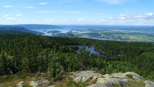
Alvdal Vestfjell is situated east of the Rondane national park. The terrain is gentler, less alpine, but you´ll still find some pointy bits (highest mountain is Storsølnkletten at 1827 m), and the weather is definitely typical of the mountains: quite unpredictable and making it essential to know how to dress properly and in general take care of yourself and look out for your hiking partner(s). Since the landscape is so open and vast, the wind easily picks up speed as it accelerates down the smooth valleys. One minute you´ll be walking in an area with just a gentle breeze and then around the corner the wind will whip your face red and make you put on your windshirt in a hurry to keep warm.

Having a lunch break out of the stiff wind. The SL-3 was great to have for this purpose!


You´ll also find green valleys with plenty of wildlife, flowers and streams and lakes with crystal clear water that you can drink without filtering (except when you spot sheep in the area). We didn´t see any wildlife except for birds, sheep (of course, what´s a holiday without stepping in sheep poop) and 1 lemming (only Joe saw that mind), but apparently there is a 1000 strong reindeer population in the area, as well as moose and wolverine. I reckon we probably were in the proximity of larger animals at some point, but I guess they heard or smelled us long before we would´ve been able to spot them.

Some flowers still thrive in the tough environment.


Soft, moist ground covered in Reindeer Moss.


Beautiful trail from Breisjøseter to Flatseter.


Places to stay
We opted to both camp and stay in cabins. The area used to have several cabins, around 6-7 I think, but nowadays there are only 3: Breisjøseter (privately owned, staffed), Korsberghytta (DNT, 13 beds, food storage) and Storgrytdalsseter (DNT, 6 beds, food storage). We ended up staying at Breisjøseter and Korsbergytta, as well as Bjørnhollia (pitched outside) when entering Rondane at the end of the trip. Our first camp was idyllic with beautiful views of the plains and a small pond right in front of us. The mozzies were around, but didn´t really bother us much.

First camp site at Follandsvangen. Slept great. Understood why there is a floor in mesh inners.


Approaching Korsberghytta. It´s the three buildings in front. There is a private cabin just next to the lake too.
Enjoying our stay at Korsberghytta. It was a bit worn down, but the food storage had lots of goodies and the visitor´s log was an interesting read :). We had the cabin to ourselves. The last visitors had been there a week ago. A couple did appear later, but chose to stay in the annex instead.


View from the living room at Korsberghytta.

At Breisjøseter enjoying a beer and a well stocked library of books about the mountains. The owner was super friendly.


The slightly scary camp
After staying at Breisjøseter we hiked down the valley, passing Flatsteter, and then changed direction to climb further up for a high camp. We were once again hiking into a stiff, cold wind. The landscape was more barren and uninviting. We´d planned to hike to three small ponds in an intersection of several valleys, but chose to set camp earlier in what seemed a sheltered spot - at least it was a lot calmer than further up as Joe found out when he went for a recon up there. We pitched our SL-3s and made sure every peg was firmly in the ground and all guylines deployed.
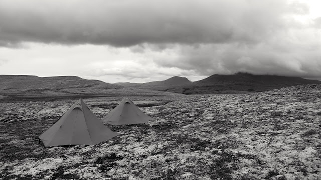
Pitched for the night.


Everything looked great, we had dinner in Joe´s crib and then retired to each of our shelters. The wind then picked up and shook our mids quite a bit, but then calmed down again. It didn´t take long before it picked up again and it started raining. I didn´t feel 100% secure that the SL-3 would be ok for the whole night so I gathered my stuff so I would be ready to move over to Joe or get out if need be. After some hours I fell asleep, waking up occasionaly when the shelter shooked. At some point it really picked up and I zipped open the door and peaked out - it looked dark, cold and alien out there. I got what I call "the awe of the mountain" feel and to be honest wished I was somewhere else, or at least in a shelter that I had more experience with.

"The awe of the mountain"


The tent did make it through the night fine though and the morning greeted us with sun and glorious views.


The definitely a bit scary mountain plateau traverse and the amazing cloud bit
After our high camp we had a long day ahead of us to cross a mountain plateau to get into the valley leading to the entrance to Rondane. A cold and stiff wind still faced us as we climbed higher, noting that setting camp the night before where we did was a great call. At some point we had to cross a snow field in blazing sunshine and with clouds passing over us at high speed. We had entered the cloud layer. Almost across the snow field I stopped and looked back to check that Joe was ok. A window in the cloud then suddenly appeared and I saw a towering cumulus cloud that was so close that it made me dizzy - it felt like watching a great mountain right in front of you, it was amazing. We both fumbled with our cameras to no avail - it was gone as soon as it had appeared.


After the snow field we reached the plateau and started heading west. It was blowing hard now, I had to hike in my Xenon. Visibiblity was low, but we were able to spot the cairns and made good progress. The thought of this section going to last 4 hours like it said on the map made me quite depressed - it was a barren, godforsaken place to travel through. Not a place you´d want to be alone in case you´d be sick or hurt yourself. With that kind of wind and temperature (4C or thereabouts) you wouldn´t be able to survive long without shelter. That´s why I´m getting one of those "Fjellduken" arctic bags before my next trip, something I never thought I´d need to carry in my pack. Thankfully we moved below the cloud cover after maybe an hour and had some great views in front of us.

Valley opening up in front of us as we got below the cloud cover.


Later that day we reached the DNT cabin Bjørnhollia after abandoning a pretty terrible camp site (wet, no proper place to put pegs, lots of mozzies) for the comfort of a well manicured lawn in front of the cabin. It also gave us access to showers and great food, something we both welcomed at this point.

Our little adventure ended the next day after hiking through Illmannsdalen and out to the Spranget parking lot where people tend to access the national park. We´ve already agreed to do another trip next year - looking forward to it! Thanks for the trip, Joe.

Tuesday, August 21, 2012

Protected

No, not from mafia thugs or an alien invasion, but from close encounters with condensation laden silnylon walls. I do love the Tarpent Moment, but being a single skin tent, and a small one at that, it is nice to have some protection.

Last morning on my trip to Krokskogen with Joe.
While in Slovenia this summer (UL Summit 2012) we had nights with no wind, high humidity and wet ground, perfect for condensation to form, and believe me it did. I remember watching the drops hanging from the roof of my tent, just waiting for a rain shower or a gust of wind to release them to a bold dive into my face or quilt. Great then that Tarptent offers a breathable, water resistant ripstop liner for the Moment and Rainbow/Double Rainbow. It attaches easily to existing hooks and loops.


After returning from Slovenia I quickly ordered liners for Helen´s Double Rainbow and my Moment. My first impression is very positive. I had anticipated to lose some of the available space in the tent, and I did, but not to an extent that it is a negative at all to me. It just feels natural to have it installed and I was surprised to feel some added warmth, but that may just be me imagining things.


After installing the liner in my Moment, and pre-attaching guylines on the sides, my Moment weighs in at 977g (excluding pegs). The cost of the liner is 30 dollars + shipping. From my first impression I highly recommend getting one, but I have of course yet to try mine in anger. I´ll report back soon :).

Please note that Moments manufactured prior to December 2010 lack two of the clips needed, but Tarptent provides them with the liner, including instructions on how to install them. It was quick and easy to sew them on. I used a sewing machine, but hand sewing works too.

22. August update

Henry Shires commented in an e-mail:

One quick note is that our documentation for the Moment liner is incorrect. We wrote that instruction sheet some time ago with the intention of actually manufacturing the two extra clips into the Moment at our Seattle factory.  That hasn't happened yet but we do install them here for people who order the Moment with liner (and send out clips for people who order liners retroactively).

Tuesday, July 24, 2012

Krokskogen loop with Joe


A weekend of bog hopping in my neighbourhood with my hiking buddy Joe Newton? After experiencing terrible weather and bug conditions in Vassfaret, hiking with Beni and Marco, I think Joe was looking forward to some sunny days in the forests and hills around Oslo.

My original intent was to take Joe to Østmarka so he could packraft and summit "Pølseberget" (Sausage mountain) which can only be done when the conditions are right and after years and years of study and mental preparation. Sausage mountain will always be there though, and I found I wanted to see if we could hike at higher altitude than we´ve done previously. The highest hills in Oslo reach up to 7-800 metres and they´re to be found in the northern area.

The book "Markas 150 beste sommerturer" described a loop of Krokskogen of 38 km which I thought looked suitable for us. Krokskogen is in the western part of Marka, an area I´d never hiked in before. From the pictures it looked interesting, offering some amazing views from the area around the hill "Gyrihaugen" (682 metres). So that´s what we ended up doing.

Joe arrived with the overnight train, trying desparately to catch some sleep while having two talkative and constantly moving italian women in the seat behind him. It didn´t help much then that NSB (national railway service) had graciously given him a luxurious kit consisting of a fleece blanket, ear plugs, eye mask and inflatable pillow. After my attempt at a fry-up at me and Helen´s place we headed downtown to find the bus to "Sollihøgda" ("T4 buss mot Hønefoss") where the trail starts. Didn´t find the bus stop in time so we had time for coffee and gear sightseeing before the next one. We almost lost the bus once more when it just drove by, the driver pointing at the other side of the street. Bolting through the heavy rain we got on the bus and we were off to a new hiking adventure. When we got off the bus at Sollihøgda we were dry again and eager to go.


It was great being on the trail again in the warm and sunny weather. A gentle breeze brought smells of flowers, grass, pine and heather to our noses. We weren´t in a big hurry so we took time to take pictures and shoot some video (I think Joe is putting one together later).


When we´re not shooting photos, we were catching up on recent events. It was very interesting to hear about the recent trip to Vassfaret. It sounded like they´d faced some really challenging conditions with awful weather and masses of bugs. I hope Beni and Marco will return to Norway at some point to have a nicer experience.


After a while we entered a lush area which reminded us both of the scenes from Endor. Joe did a Chewbacca impression which made made me laugh.


The trail is very varied, but it´s not the most maintained. Trees had fallen over it at places, some trail markings were in need of refreshing and so did some of the signs. We were now climbing steadily, closing in on Gyrihaugen and our planned camp close to a small lake.

The trail was at times muddy and boggy, but never as bad as last year when we hiked Jotunheimstien, after an especially wet summer, which also meant that the bugs had a lot of catching up to do - yes, that meant sucking blood form as many humans as possible in the shortest time possible. Believe me, we noticed. On this hike we didn´t see many mosquitoes, but the noseuums were out at times and were having a field day until we got out our headnets.


After a while we realized that we´d chosen the wrong trail at a junction, but that was a lucky coincidence as the trail went parallell with the cliff to the west of the hill. We were 5-10 meters from it but in a strange way I could feel the dropoff beyond the edge. The views were beautiful though with a sense of looking down at the landscape, like from an airplane.


It was great getting to camp, having some dinner and relaxing after a long day hiking.

View from camp.


I used my Tarptent Moment, Joe his SpinnTwinn and Yama 1.25 bug shelter.


Joe cooking dinner with his Ti-Tri. He did a good job, especially since he wasn´t using the Inferno insert with it.


We were both surprised to see the temperature drop to 4-5 C during the night, making it quite chilly. My "new second hand" Neoair short surprised me by leaking, even after I had repaired it the night before the hike and tested it. I ended up having to reinflate it 2-3 times during the night, not exactly helping warmth and sleep. Luckily I had brought a section of CCF to sit on that I could place under my torso for some extra insulation.

The next day was as beautiful weatherwise as the first. Joe even made me a steam baked muffin which combined with some nice coffee gave me a great start to the day!

Mmmmm, steamed baked chocolate muffin, gooey inside.


Close to camp there is a geographical feature that has been given the name "Mørkegangen", a spectacular crack in the hillside with a very steep path leading through it. A ferrata style metal hand rail has been placed on one side so that hikers have some support while going up. It´s not dangerous to walk up, but quite physically demanding since so much height has to be gained in such a short distance. After breakfast we decided to take a look it. We hiked maybe 500m and then arrived at the very top of it.  We´d talked to some locals the day before that said it´s not recommended to descend it, so we just watched the views and took some pictures. The drop down to the forest floor below is huge and it felt pretty exposed. I wouldn´t have brought kids up there for sure, or any person that isn´t predictable. For us two though it was a great experience. Fantastic views. I would never have guessed we have something like this near Oslo.


A scary place to stand.

All smiles, we continued on the trail, climbing up to the vantage point, Gyrihaugen, which provided views in all directions.

Tough going.
But well worth it for the views. Strange to see a lake/pond so close to the drop off beyond it.

The rest of the day was spent walking trails through the forest, now turning south towards our destination, Skansebakken. We saw very few people on the trail, in fact we only met 2 persons on the trail during the first day.

Lunch was had at Løvlia, a place that we hoped would provide waffels, cinnamon buns, soda and the like, but turned out to be closed for the summer and being taken over by sheep who had pooed all over the place. Still we found a bench and table where we could sit down and enjoy the sun and more of the savory, fatty raindeer sausage that Joe had brought. After a while a bird photographer turned up and joined us. He was just out for a day walk and had also believed the place to be open.

After lunch we studied the map and saw the blue fork and knife icon next to a place called Heggelia. Burgers and fries and other naughty food was on our mind as we closed in on that place some hours later, only to find out that they too only served food during winter. We could get some limonade the old lady said, but we passed on that offer, instead moving on to find camp. Turned out it was a long road walk to the place we had planned to camp, and then it started raining. After maybe half an hour the old lady came driving in her red car and gave us a lift to the lake "Søndre Heggelivann" where she said people use to camp. She had the heater on full and sitting in the front seat, close to the heater, I immediately started drying, steaming up part of the front window. We probably didn´t smell that great either :). After she dropped us off we spent quite a while finding a place to camp, ending up pitching in the forest and eating our dinner close to the lake.

Taste this! (Dates and apricot couscous with raindeer sausage, it was nice actually)


As I lay in my tent with the sun going down I had a great display of color and shapes on the tent fly.


The view wasn´t as nice the next morning when I had heaps of condensation, some of it dripping on me. No surprise really since the ground was damp from the rain shower the previous evening and since it was chilly and no wind. Going to get the liner for the Moment for these conditions.


Joe had condensation on his tarp too, which goes to show that ventilation isn´t enough under certain conditions.

We now only had 8 km to the finish line, so we again took time to shoot video and take pictures.

Joe setting up a video shot.
And so ends another great hike with Joe. I hope we get to hike again next summer.